01
Open Google Maps in your browser
Navigate to the area you want to capture and zoom to your desired detail level. Street map, satellite, or hybrid layers all work.
Download map tiles and satellite imagery for any rectangular area so you never lose your way when the signal drops.
Stay oriented even when you’re miles from the nearest cell tower. This extension lets you capture street map, satellite, or hybrid tiles before you head out, so your directions and landmarks are always at hand.
Simply drag a box over the area you need and download at your chosen zoom level. The progress bar shows exactly how many tiles are done and how long until completion, keeping you informed every step of the way.
Everything is stored on your device with zero telemetry. Whether you’re hiking, driving through remote backroads, or preparing for a work trip, you’ll have the map you need without relying on a live connection.

Trusted by 40k+ SERP Apps users.
Private downloads. No ads or tracking.
Part of the SERP Apps Extensions Library.
Open the page, let the extension detect what is available, and save the file to your computer.
Navigate to the area you want to capture and zoom to your desired detail level. Street map, satellite, or hybrid layers all work.
Click the extension icon and drag a bounding box over the area you need. The extension calculates the total tile count and estimated download size.
Pick the map layer, zoom level, and download speed. Higher zoom captures more detail but produces more tiles.
Short, practical feedback from people using Google Maps Downloader in real workflows.
I do geological surveys in remote desert areas. Having satellite tiles on my laptop before heading out saves hours of guesswork and keeps the team on track.
Carlos Medina
2025-02-10
Downloaded street-level tiles for a delivery route analysis project. The coordinate naming made it painless to stitch everything in QGIS.
Priya Nair
2025-03-08
Took satellite imagery of our ranch property for a fence-line dispute. Way easier than trying to screenshot and stitch manually.
Tom Andersen
2025-01-22
These comments and ratings were collected during our July 2026 customer survey and reviewed against support records before publication.
Core capabilities included in Google Maps Downloader.
Designate any rectangular area on Google Maps and capture all visible map tiles at your selected zoom.
Switch between street, satellite, and hybrid overlays before you begin capturing map data.
Coordinate-based file naming makes importing into your preferred GIS and mapping software straightforward.
Fine-tune the download pace to stay within Google’s rate limits and keep your account secure.
A live progress panel reports completed tiles, remaining count, and estimated time until finished.
Route overlays for driving, walking, and cycling directions are saved as separate image layers.
The extension keeps your choices and licence info on your device without sending any usage data.
A right-click context menu lets you pick a capture zone instantly, bypassing the toolbar popup.
Designed to operate on Chrome, Edge, Firefox, Brave, and Opera for Windows, macOS, and Linux.
Open your browser to Google Maps, locate the target region, and set the zoom for your needed detail.
After clicking the extension icon, drag a bounding rectangle; the tool calculates tile count and approximate download size.
Choose your preferred map layer, zoom depth, and transfer speed; greater zoom yields richer detail but more tiles.
Pick your map type, zoom, and capture zone with predictable results instead of guessing what a site will return.
Google Maps Downloader
Switch between street, satellite, and hybrid overlays before capture
Online Map Tool
Layer options may be limited or differ on an external site
Google Maps Downloader
Coordinate-based file naming for direct GIS import
Online Map Tool
File names from a web tool may lack geospatial reference
Google Maps Downloader
Fine-tune the download pace to respect rate limits
Online Map Tool
An online tool may not offer speed control, risking access issues
Google Maps Downloader
Adjust zoom depth for the exact detail you need
Online Map Tool
Zoom levels can be fixed or unpredictable on another website
Google Maps Downloader
Route overlays saved as separate image layers
Online Map Tool
Direction overlays are rarely preserved by generic downloader sites
Google Maps Downloader
No ads or redirects interrupt your map capture workflow
Online Map Tool
Some free sites may show ads or redirects before providing tiles
Available on major desktop browsers and operating systems used in day-to-day workflows.
Pick the browser build you need. When a direct GitHub release is available, you can grab the ZIP there.
Chrome support is in progress and will be enabled soon.
Firefox support is in progress and will be enabled soon.
Edge support is in progress and will be enabled soon.
Opera support is in progress and will be enabled soon.
Brave support is in progress and will be enabled soon.
Whale support is in progress and will be enabled soon.
Yandex support is in progress and will be enabled soon.
Install from GitHub releases or your user dashboard. ZIP builds include the full desktop extension.
Every requested permission and the job it performs inside the extension.
Saves captured map tiles to your downloads folder and tracks progress for each file.
Stores the licence key, preferred zoom levels, and layer settings between sessions.
Reads the currently visible Google Maps tab to identify the map viewport and available tile layers.
Injects the bounding-box selector overlay and extracts tile URLs from the Google Maps page.
Sends a desktop alert when all tiles in a region have finished downloading.
Adds a right-click option to quickly start a tile capture from any Google Maps view.
Restricts privileged access to google.com/maps and its tile-serving subdomains.
Better to know the boundaries up front than find out after checkout.
Does not capture Street View, 3D buildings, or real-time traffic layers
Large regions at high zoom levels may produce thousands of tiles and take significant time
Tile availability and detail depend on what Google Maps renders for each area
Safari and mobile browsers are not supported
Downloaded tiles are static images and do not update automatically
Route overlays are rasterized and cannot be edited after download

Download YouTube videos from the watch page, choose an available quality, and save the completed file to your computer.
TikTok videos always contain both audio and video in a single MP4 file, but sometimes you just want the audio track — to save music, quotes, or background...
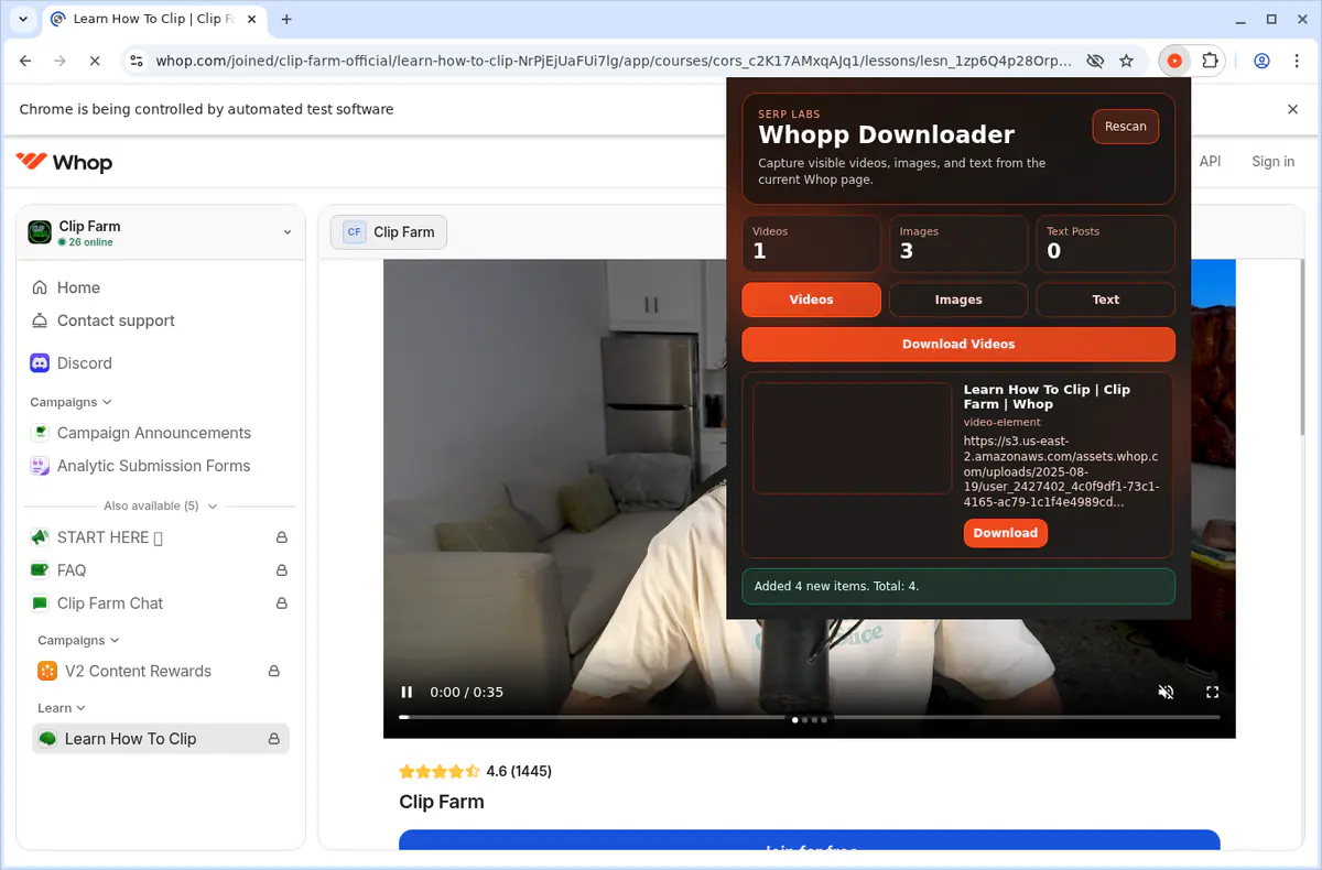
Download Whop videos from the lesson or post open in your browser. Find the video, scan the page, save the MP4, and check the result.
Keep exploring
Browse every category we support and jump directly into the tools that match your workflow.
23 categories are currently available.
Immediate Access
Product access begins after a successful checkout
Setup Guidance
Installation steps are provided for the supported package
Billing Shown Upfront
Review the selected billing interval before checkout
Navigate confidently in dead zones with locally stored map tiles and satellite imagery
Build georeferenced archives for field research, urban planning, or logistics
Prepare route visuals for presentations and reports without relying on live connections
Keep all captured data private with fully on-device processing